 |
Information linking spatial coordinates (world coordinate system or WCS) to image pixel coordinates is inserted into the headers of the FITS images derived from these surveys. Descriptions of standard projective systems are now being standardized (Greisen and Calabretta 1995a, 1995b). The Digitized Sky Survey, scanned from photographic plates rather than created from digital detectors, provides plate solutions with each extracted image. All that was needed was an easy-to-use viewing program which could display WCS information.
When the wealth of available WCS-containing FITS-format information became
apparent, steps were taken to add world coordinate access to
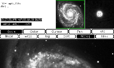
SAOimage. Both cursor tracking in sky coordinates (see figure 1) and the
ability to export cursor positions as sky coordinates were added to the
program. Additional capablities have been added as users requested them
and new data formats became available.
 |
| CTYPE value | Projection | Comment |
| -AIT | Hammer-Aitoff | equal-area all-sky |
| -ARC | Zenithal equidistant | closest to a Schmidt plate |
| -CAR | Cartesian | linear, default |
| -GLS | Samson-Flamsteed | global sinusoidal projection |
| -MER | Mercator | |
| -NCP | North Celestial Pole | polar |
| -SIN | sinusoidal | orthographic |
| -STG | Stereographic | zenithal orthomorphic projection |
| -TAN | tangent plane | gnomonic |
The option of displaying or exporting coordinates in systems other than that used in which the image header was added in version 1.14. Subroutines derived from Patrick Wallace's SLALIB positional astronomy library (Wallace 1994) were used to translate between FK4, FK5, and galactic coordinate systems. Version 1.17 extended WCS access to IRAF OIF images, by internally translating IRAF headers to FITS headers and extracting parameters using the code already used for FITS files.
hh:mm:ss.sss dd:mm:ss.ss;galactic latitude and longitude are printed as
dd.ddddd dd.ddddd.If WCS information is not available in the header, only pixel coordinates and value are returned.
In version 1.14, commands were added to SAOimage to print the world coordinates of the current cursor position in any of three coordinate systems. Coordinates will be converted if this is not the same system as that in the image header. b prints the current cursor coordinates in the B1950 (FK4) system as hh:mm:ss.sss dd:mm:ss.ss B1950 . j prints the cursor coordinates in the J2000 (FK5) system as hh:mm:ss.sss dd:mm:ss.ss J2000 . g prints the cursor position in galactic coordinates as dd.ddddd dd.ddddd galactic . If SAOimage is being used to look at a local image, output will be to the window from which SAOimage was invoked. If SAOimage is being used with Mosaic, output is sent to the console window. Netscape sends output from helper applications to a new window, but not until several lines have been sent.
Additional command line flags set the format in which the world coordinates of the current cursor position will be displayed. The same position string that is displayed above the pixel coordinate in the SAOimage window is sent to standard output when the "c" command is used and to an external program when the "w" cursor command is issued.
Adding the switch -fk4 or -b1950 to the command line causes the cursor to track in FK4/B1950 right ascension and declination. The coordinates in hours, minutes, and seconds of right ascension and degrees, minutes, and seconds of declination will put into a string of the format hh:mm:ss.sss dd:mm:ss.ss B1950 .
The switch -fk5 or -j2000 makes the cursor track in FK5/J2000 right ascension and declination, displaying hh:mm:ss.sss dd:mm:ss.ss J2000 .
The command line switch -galactic (which may be shortened to -gal) causes the cursor to track in galactic longitude and latitude. The coordinates in decimal degrees will be displayed to five decimal places in the format dd.ddddd dd.ddddd galactic . Leading zeroes are dropped.
To search the Hubble Space Telescope Guide Star Catalog in a 30-arcsecond-square region centered on the current cursor position using the RGSC program, add -wcscom rgsc_%s_-box_0:00:15 to the saoimage command. When the cursor is centered on the star in the upper right corner of figure 1, the "w" command prints the following:
HST Guide Stars B1950

HSTGSC at  13:27:32.976   47:29:10.88 30" x 30" (B1950)

3460.0534  13:27:32.285   47:29:04.27 14.98 0 1     9.87
image/x-fits fit fits fts FIT FITSand this line to your .mailcap file
image/x-fits; saoimage -fits %sTo serve FITS files from a http server so that SAOimage will be invoked to browse them, add this line to the httpd srm.conf file:
AddType image/x-fits .fit .fits .fts .FIT .FITSand make sure that any FITS files on your server have one of those extensions.